欢迎大家赞助一杯啤酒🍺 我们准备了下酒菜:Formal mathematics/Isabelle/ML, Formal verification/Coq/ACL2/Agda, C++/Lisp/Haskell
MapGuide Open Source
| |
您可以在Wikipedia上了解到此条目的英文信息 MapGuide Open Source Thanks, Wikipedia. |
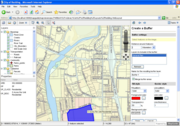
MapGuide Open Source is a web-based platform that enables users to quickly develop and deploy web mapping applications and geospatial web services. MapGuide features an interactive viewer that includes support for feature selection, property inspection, map tips, and operations such as buffer, select within, and measure. MapGuide includes an XML database for managing content, and supports most popular geospatial file formats, databases, and standards. MapGuide can be deployed on Linux or Windows, supports Apache and IIS web servers, and offers extensive PHP, .NET, Java, and JavaScript APIs for application development. MapGuide Open Source is licensed under the LGPL.
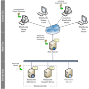
MapGuide 由四个主要组件构成:MapGuide Server、MapGuide Studio、MapGuide Web Server Extensions 和提供了两种浏览方式的 MapGuide Viewer。 MapGuide Studio 需要另外购买。也提供 MapGuide Open Source Web Studio。
目录 |
新特性
Autodesk MapGuide 用户最欣赏的 10 个MapGuide 新特性, 也部分适用 Open Source 版:
- 增强了出图功能,包括 DWF 技术、脱机查看属性和移动功能
- 使用图形用户界面的自动导入程序把数据加载到服务器上
- 直接连接到FDO数据源,如 SDE,Oracle Spatial 和 OGC
- 有效的区分开不同数据源中的地图标注和标记
- 通过 MapGuide Studio 快速完成基于 HTML 的地图发布,而不需要安装插件
- 能在 Studio 里完成数据载入、数据连接和地图发布等操作
- 基于 Web 的服务器管理工具
- 用于创建定制地图应用的服务器端 API
- 三种语言(Java,PHP.NET)的完整 FDO API,可用于高级空间查询
- 支持 Linux 服务器
Links
Install
从 获得 http://download.huihoo.com/mapguide/ 获得安装包
先安装 Server, 如 MgServerSetup-1.2.0.exe
再安装 Server Extensions, 如 MgWebServerExtensionsSetup-1.2.0.exe
使用默认 8008 端口,因为有些应用已绑定这个端口。
选择 php 或 java 编程环境。
http://localhost:8008/mapguide/mapadmin/
http://localhost:8008/mapguide/mapviewerphp/
http://localhost:8008/mapguide/webstudio/
用户名/密码: Administrator/admin
API
有许多 API 可以用来在MapGuide中开发。假如您想定制 Autodesk MapGuide Studio 的某些方面,或使之自动化,那么可以使用API。假如您想访问要素几何的某些方面,您就能用 FDO API 来改变、操作、重投影或分析这些要素。下面的这些API对开发者来说是有用的:
- 资源服务(Resource Service) 使您能够处理数据存储和资源。也能够用来载入数据
- 要素服务(Feature Service) 提供了对 FDO provider 的访问
- 地图服务(Mapping Service) 提供了对地图和图层的访问
- 绘图服务(Drawing Service) 允许对绘图资源进行低级访问。能处理 DWF文件
- 展示服务(Rendering Service) 将一副地图转换成位图格式的图像。主要用于在HTML Viewer 里显示图像
- 坐标系统(Coordinate System) 支持坐标系统的转换
- 几何(Geometry) 处理几何对象
- 站点服务(Site Service) 配置用户,组和用户群
Database
FDO Data Access Technology is an API for manipulating, defining and analyzing geospatial information regardless of where it is stored.
MapGuide在演示中使用了 dbXML 作为数据的存储方式。如:
MapGuideOpenSource\Server\Repositories\Site\MgSiteResourceContents.dbxml

